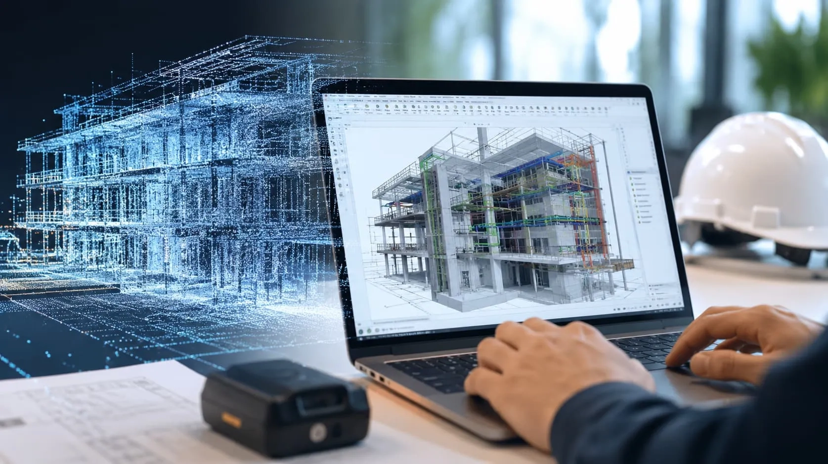
Choosing the right point cloud software is crucial for your architecture, construction, or restoration project. It can help you turn complex data into useful 3D models. But with so many options available, picking the best one can be a bit tricky. In this guide, we will look at the important things to think about when you're making up your mind. So, let's dive in and find the perfect software for your project!
Define Your Business Goals for Point Cloud Software Selection
The first thing you need to do is figure out what your business is all about and what you want to achieve with point cloud software. For instance, if your main job is to gather data, and your responsibility ends when you hand over that data to your customers, then your main focus should be on picking the best point cloud software. This software should help you collect data efficiently and accurately. It should also have tools to line up and merge different scans or images to create a complete and organized point cloud dataset.
However, if your business involves transforming point cloud data into CAD documents like 2D drawings, topographic plans, 3D models, or BIM models, and delivering them to architects, engineers, civil engineers, constructors, BIM managers, cultural heritage specialists, designers, or manufacturing companies, then you'll need a reliable solution for converting point clouds into CAD deliverables.
Now, if your business offers a wide range of services, from collecting data to turning point clouds into the documents your customers need, then you'll need software that can both generate a point cloud and handle point cloud modeling tasks.

Data Capture & Point Cloud Generation using the Right Point Cloud Software
If your business is all about capturing data and creating point clouds, the first thing you should think about is the equipment you use. The hardware you choose will directly affect how good, precise, and efficient your data gathering process is. It might not sound very exciting, but from our nearly twenty years of experience in reality capture projects, we've found that the best software to create and work with point clouds usually comes from the same company that made your hardware. For example, if you use a Trimble scanner, it's easiest to process the data with Trimble Realworks software, and if you use a Leica scanner, you'll have an easier time with Leica Cyclone REGISTER 360 software, and so on.
But when it comes to making point clouds using photogrammetric software, you've got more choices. Some of these options include RealityCapture, Agisoft Metashape, PIX4Dmapper, 3DF ZEPHYR, DroneDeploy, and Visual SFM. These software solutions also support a variety of file formats like *.PTX, *.LAS, *.LAZ, *.PTS, *.PLY, and custom ASCII / TXT files. These days, all reality capture solutions allow you to deliver point clouds in universal formats that can be used with any CAD application, like *.E5.
So, choosing the right hardware and software is crucial for getting the best results when working with point clouds in your data capture projects. It may not be the most thrilling part of the job, but it's definitely important!

Producing 2D & 3D Deliverables with Point Cloud Software
If your company is focused on creating 2D and 3D designs from point cloud data, you need to choose the right software for the job. Look for software that is specifically designed for turning point cloud data into CAD drawings. This software should be able to effectively extract the necessary information from the point cloud and convert it into CAD-compatible formats like DWG, RVT, IFC, SKP, and PDF.
When working on 2D designs, it's important to ensure that the CAD software you select has accurate measurement tools, easy layer management, and annotation features. These tools will help you create precise and detailed 2D representations based on the point cloud data.
For 3D modeling, your chosen software should have features that allow you to create detailed and accurate 3D models using the point cloud data. This includes functions like surface modeling, solid modeling, and meshing.
If you want to integrate your point cloud data into BIM platforms like Revit, consider software that offers this integration. This way, you can transform your point cloud data into BIM models, which can be used by your clients in various stages of design, construction, and facility management.

Converting Point Clouds into DWG, RVT/IFC and SKP Models using Point Cloud Software
DWG Drawings
If you want to change point clouds into DWG drawings, two good software options are AutoCAD and ARES Commander with the Undet plug-in. These tools make it easy to create 3D models and 2D drawings from 3D laser scan data. You can also adjust the DWG drawings to match your specific project needs, like changing layers and line weights to fit your standards.
RVT / IFC models
For converting point clouds into BIM models, Revit is the way to go. Revit is a strong computer program that architects, engineers, and builders use. However, it lacks specialized tools for point cloud processing, but you can solve this by using the Undet for Revit plugin. It makes working with point clouds in Revit simpler and more efficient with user-friendly tools and an intuitive interface.
SKP models
If you're working with SketchUp for 3D modeling and need to handle point clouds, the Undet plugin is the answer. SketchUp is a popular software for creating 3D models, but it doesn't have dedicated point cloud tools. The Undet for SketchUp plugin fills this gap, allowing SketchUp users to seamlessly integrate point cloud data into their models, making the process easier and more efficient.
How to choose the right point cloud modeling software for you?
When you're picking the right software for modeling point clouds, there are a few things to keep in mind:
Compatibility: Make sure the software you choose works with the kind of data your scanner generates. This data usually comes in formats like E57, LAS (from LiDAR), PTS, PLY, XYZ, and PTX.
Functionality: Take a close look at what each software can do. Think about what you need, and see if the software has the tools to do it. Some software might even help you do things faster with automation.
Ease of Use: It's a good idea to go for software that's easy to use. It can help you work faster and be a friendlier experience for new and experienced users. Look for software with simple interfaces and good support from the people who make it.
Cost: Figure out how much you can spend on this software. Compare the price to what it offers. Some software makers let you try it for free for a while, which can help you decide if it's worth your money and time.
Read more: Point cloud to BIM services - Scan to BIM Services - BIM Outsourcing
Recommended Point Cloud Software
Many software options are available for working with point clouds. These programs have their own strengths and weaknesses. Here are some of the popular CAD software programs that work well with Undet's plugins to make point cloud modeling easier and faster:
Autodesk AutoCAD: AutoCAD is a well-known CAD program used for point cloud modeling. When combined with Undet's tools, it becomes even more powerful for managing point clouds efficiently.
ARES Commander: ARES Commander is an affordable alternative to AutoCAD. By using Undet's tools with ARES Commander, you can quickly and easily convert point clouds into 2D drawings without breaking the bank.
Autodesk Revit: Revit is a comprehensive Building Information Modeling (BIM) software that supports point cloud modeling (scan2bim). Undet for Revit software offers the tools you need to speed up and simplify point cloud modeling within Revit.
Trimble SketchUp: SketchUp is a user-friendly 3D modeling software. Undet for SketchUp provides a variety of advanced tools for point cloud modeling, making it a great choice for those who prefer an intuitive design interface.

We come from Harmony AT - a Vietnamese company specializing in providing point cloud to BIM services. You are looking for a good, responsible partner, congratulations! This is our contact line. Get in touch whenever you want.
Categories